
3D Urban Models for 2026:
3D urban models are revolutionizing how cities plan for 2026 and beyond. Smart city planning tools now integrate real-time data, AI-powered design automation, and collaborative visualization to help urban planners, developers, and municipalities make better decisions faster.
This guide is for urban planners, real estate developers, architects, and municipal teams who need to navigate the evolving landscape of 3D urban planning software and digital twin city planning. You’ll discover how these technologies can streamline your workflow from initial site analysis to final stakeholder approval.
We’ll cover Understanding 3D Urban Models and Digital Twins – explaining how modern urban digital twins go beyond static visualizations to create data-rich environments that simulate real-world conditions. You’ll also learn about Essential Features for Effective 3D Urban Planning Software, including the must-have capabilities that separate basic modeling tools from comprehensive urban development platforms. Finally, we’ll walk through Streamlined Workflow: From Data Collection to Decision Making, showing you how to integrate multiple data sources and automate complex analyses to accelerate your planning process.
The shift from traditional 2D blueprints to interactive 3D city models isn’t just about better visuals – it’s about making smarter, data-driven decisions that create more sustainable and livable cities.
3D Urban Models for 2026:
Understanding 3D Urban Models and Digital Twins for Modern Planning
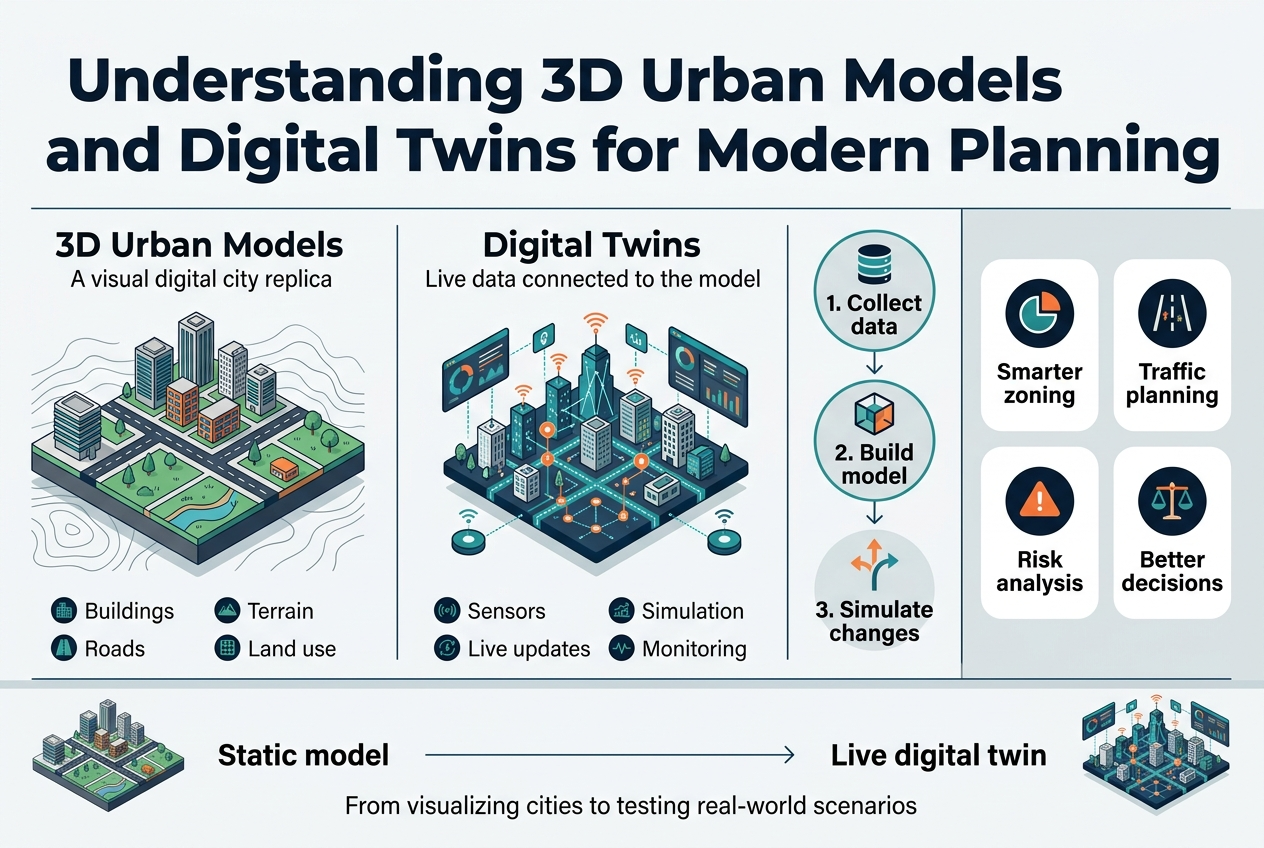
What Makes 3D Urban Models Different from Traditional CAD and BIM
3D urban planning software represents a fundamental shift from conventional design tools, creating dynamic, data-driven platforms that generate interactive, geographically accurate digital replicas of entire urban environments. Unlike traditional CAD systems that focus primarily on individual objects or architectural visualization tools that prioritize aesthetic presentation, 3D city models operate as comprehensive urban intelligence platforms.
The distinction becomes even clearer when comparing these tools to Building Information Modeling (BIM). While BIM excels at detailed building-level analysis, digital urban modeling operates on a macro-level perspective, focusing on the broader urban environment, infrastructure networks, and the complex relationships between multiple buildings and public spaces. This macro-level approach enables large-scale analysis that traditional tools simply cannot accommodate.
The Power of Geospatial Data Integration and Real-World Context
The transformative power of modern urban planning technology 2026 lies in its sophisticated integration of Geographic Information Systems (GIS) data. This integration transforms static designs into rich, queryable 3D environments layered with comprehensive real-world context.
These platforms seamlessly incorporate multiple data layers including terrain modeling, existing building databases like 3D BAG, infrastructure networks, cadastral boundaries from sources like Kadaster, zoning regulations, and underground utility systems. This multi-layered approach creates a foundation where planners can analyze complex urban relationships and make informed decisions based on accurate, contextual information rather than isolated design elements.
3D Urban Models for 2026:
How Digital Twins Transform Static Models into Dynamic Planning Tools
Urban digital twins represent the evolution beyond static 3D models, creating dynamic, virtual replicas of physical cities or development areas. These sophisticated systems integrate real-world data streams from environmental sensors and traffic management systems, enabling planners to simulate impacts and assess scenarios in real-time.
Unlike traditional models that provide snapshots in time, digital twins become operational tools for ongoing city management. They continuously update with live data, allowing planners to observe how proposed changes might interact with current urban conditions and predict long-term impacts through 3D urban simulation capabilities.
Key Stakeholders and Their Specific Use Cases
Smart city planning tools serve diverse stakeholder groups, each with distinct requirements and applications:
Urban Planners leverage these platforms for comprehensive master planning initiatives, analyzing zoning policy impacts, and conducting detailed environmental studies including shadow analysis and wind pattern modeling. The macro-level perspective enables them to understand city-wide implications of development decisions.
Real Estate Developers utilize the technology for rapid site selection processes, conducting data-backed feasibility studies, and creating accurate financial modeling systems like GREX. The integration of real-world context data allows for more precise risk assessment and investment decisions.
Architects employ these tools to place conceptual designs within authentic real-world contexts, understanding how new buildings will interact with existing urban fabric and infrastructure systems.
Municipalities leverage digital twin city planning for managing public assets efficiently, engaging citizens through clear visualizations of proposed developments, and maintaining comprehensive city-scale digital twins that support ongoing urban management and policy decisions.
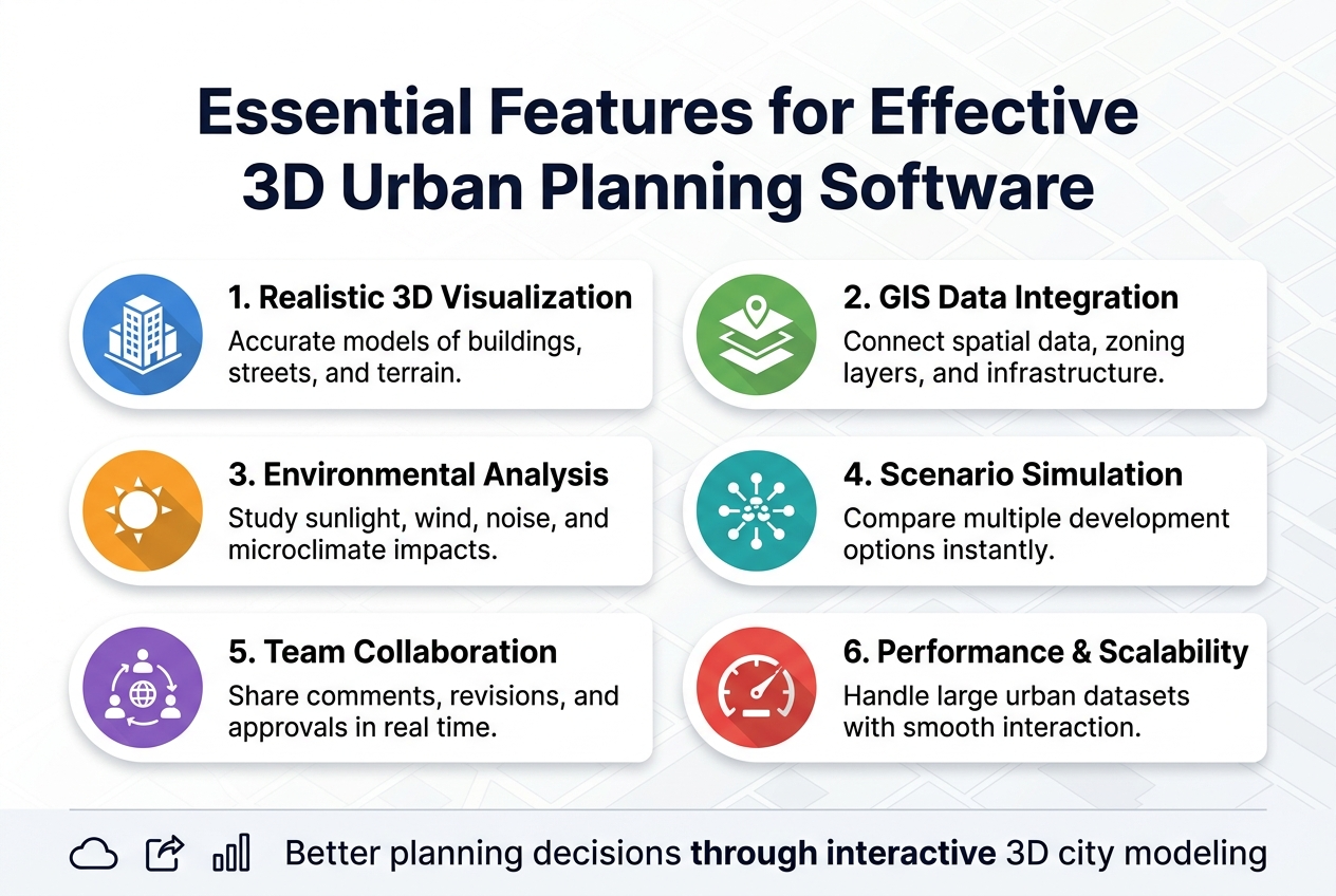
Essential Features for Effective 3D Urban Planning Software
Data Integration Capabilities and Format Compatibility
Modern 3D urban planning software must seamlessly integrate with diverse data sources while maintaining compatibility with standard industry formats. Essential format support includes CAD, BIM, GIS, IFC, and SketchUp files, ensuring your team can work with existing data assets without conversion barriers. This comprehensive compatibility eliminates workflow disruptions and reduces project timelines significantly.
For specific markets, direct access to national and local datasets becomes crucial for accurate modeling. Integration with specialized databases like 3D BAG and Kadaster provides immediate access to verified building information and cadastral data. Additionally, below-ground utility data integration enables comprehensive infrastructure planning that accounts for existing underground systems, preventing costly conflicts during development phases.
Modeling and Design Tools for Rapid Scenario Creation
Top-tier 3D urban planning software incorporates parametric design capabilities that generate models based on predefined rules and data inputs. This automation dramatically accelerates the scenario creation process while maintaining consistency across different development options.
AI-powered features represent the cutting edge of urban modeling technology, automatically generating building typologies and entire area developments based on zoning requirements and design parameters. These intelligent tools reduce manual modeling time while ensuring compliance with planning regulations.
Intuitive drawing tools complement automated features, providing flexibility for custom massing models and infrastructure design. These tools enable planners to quickly sketch concepts and refine them into detailed 3D representations, bridging the gap between initial ideas and comprehensive urban digital twins.
3D Urban Models for 2026:
Analysis and Simulation Functions for Impact Assessment
Effective 3D urban planning software transforms visual models into powerful decision-making engines through comprehensive analysis capabilities. Environmental analysis functions provide instant shadow impact assessments, line-of-sight evaluations, and noise hindrance modeling, enabling planners to understand and mitigate negative impacts before implementation.
Financial analysis integration represents a critical feature for viable urban development. Software should include modules for land exploitation plans (GREX) with real-time cost and revenue calculations displayed in Euros. This immediate financial feedback allows teams to optimize development scenarios for both community benefit and economic viability.
Scenario planning capabilities enable side-by-side comparison of multiple development options, facilitating data-driven decision making. This comparative analysis helps stakeholders visualize trade-offs and select optimal development paths based on quantifiable metrics.
Collaboration and Visualization Features for Stakeholder Engagement
Cloud-based platforms enable seamless sharing of interactive 3D city models without requiring specialized software installations for stakeholders. This accessibility democratizes urban planning discussions and ensures all participants can engage meaningfully with proposed developments.
High-quality, real-time 3D rendering capabilities create compelling presentations that communicate complex planning concepts effectively. These visualizations bridge technical expertise gaps, allowing non-technical stakeholders to understand spatial relationships and urban impact assessments.
Built-in commenting and annotation systems streamline feedback collection and collaboration workflows. These features centralize communication around specific model elements, accelerating consensus building and ensuring all stakeholder input is captured and addressed systematically.
Streamlined Workflow: From Data Collection to Decision Making
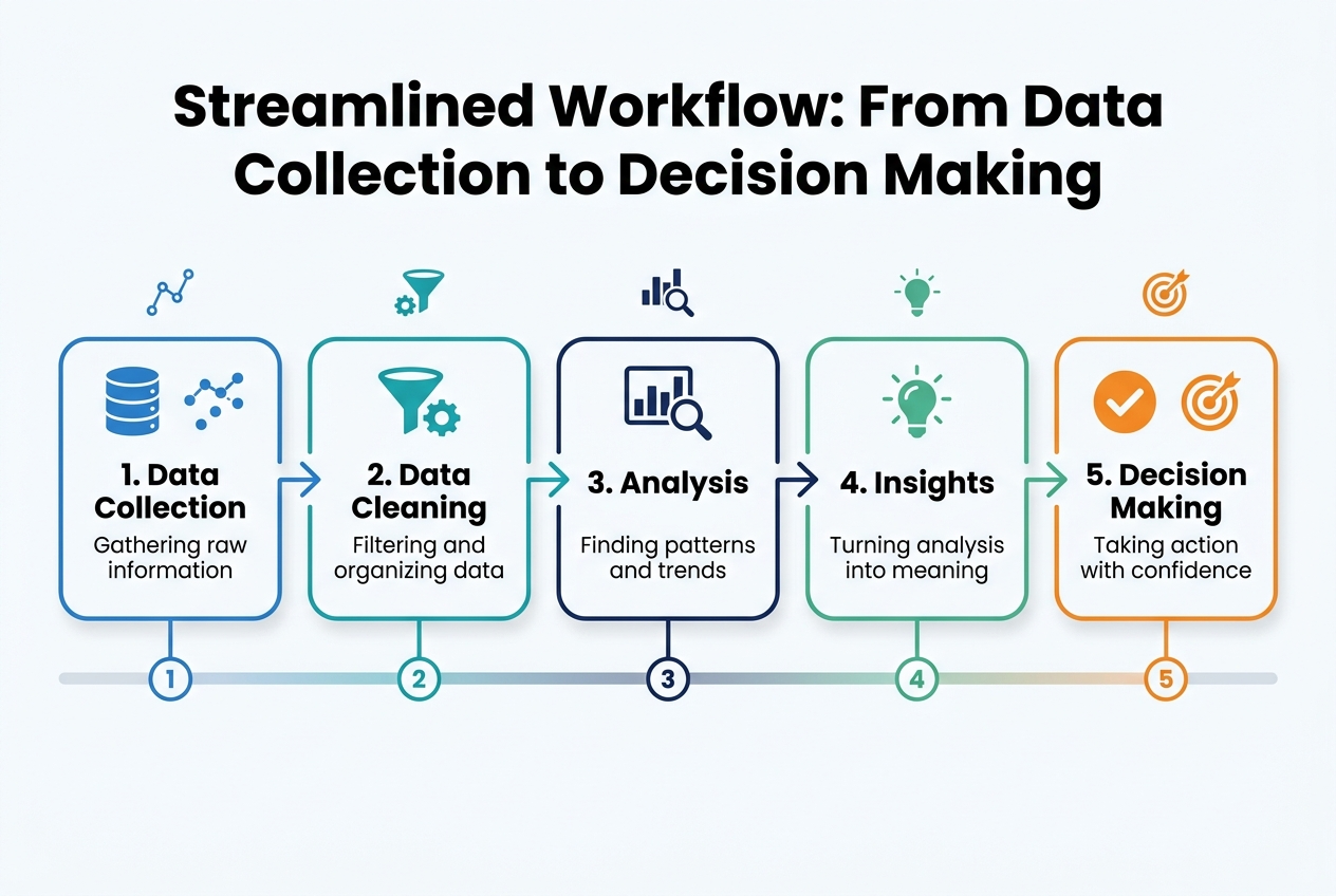
Site Analysis and Automated Data Aggregation
Modern 3D urban planning software begins with sophisticated automated data aggregation capabilities that revolutionize how planning professionals approach site analysis. This foundational phase involves the instant collection and integration of crucial geospatial information, creating a comprehensive baseline for all subsequent planning activities.
The automated aggregation process seamlessly pulls together topographical data, existing building footprints at both LOD1 and LOD2 detail levels, current zoning regulations, and critical underground infrastructure mapping. This comprehensive data collection creates a robust digital twin city planning foundation that provides immediate clarity on both existing constraints and emerging opportunities within the urban environment.
By automating this traditionally time-intensive process, planning teams can rapidly establish a foundational urban digital twin that serves as the authoritative source for all design decisions. This automated approach eliminates the manual data collection bottlenecks that previously delayed project initiation and ensures that all team members work from the same accurate, up-to-date information baseline.
Conceptual Design and Parametric Scenario Modeling
With the foundational data in place, 3D urban simulation capabilities enable rapid conceptual design development through intuitive drawing tools and generative design features. Planning professionals can leverage these advanced smart city planning tools to quickly sketch multiple development concepts directly within the three-dimensional environment.
The parametric modeling capabilities allow for real-time modification of key design parameters, enabling teams to test various building typologies, density configurations, and public space layouts within minutes rather than weeks. This dynamic approach to digital urban modeling transforms the traditional design process by providing immediate visual feedback on design decisions.
The ability to rapidly iterate through multiple scenarios empowers planning teams to explore creative solutions while maintaining technical accuracy. Each parametric adjustment instantly updates the 3D model, allowing stakeholders to visualize how different design choices impact the overall urban fabric and community dynamics.
Real-Time Feasibility and Environmental Impact Analysis
Advanced 3D visualization urban planning platforms integrate design processes directly with analytical capabilities, providing instant calculation of key performance indicators for each proposed scenario. This real-time analysis capability represents a significant advancement in urban planning technology 2026 workflows.
The system automatically generates comprehensive feasibility metrics, including detailed financial viability assessments with automated GREX calculations and precise cost-revenue analysis in Euro. Environmental impact evaluation occurs simultaneously through sophisticated sun and shadow path simulation, providing immediate insight into how proposed developments affect surrounding areas.
Quantitative metrics are calculated instantly, covering essential planning indicators such as Gross Floor Area calculations, residential and commercial unit counts, parking allocation, and green space percentages. This immediate feedback loop enables planners to make informed decisions during the design process rather than discovering issues during later review stages.
Interactive Stakeholder Communication and Approval Process
The final workflow component transforms traditional stakeholder engagement through interactive, web-based 3D city models that replace static 2D blueprints with dynamic visualization experiences. These urban development software platforms enable realistic visualizations and immersive virtual walkthroughs that help stakeholders understand proposed developments with unprecedented clarity.
This collaborative digital environment significantly simplifies the feedback collection process while enabling real-time revisions based on stakeholder input. The interactive nature of these presentations builds stronger consensus among diverse stakeholder groups, ultimately streamlining the approval process and securing necessary buy-in for project advancement.
The web-based accessibility ensures that stakeholders can review and provide feedback on proposed developments from any location, facilitating more inclusive participation in the planning process while maintaining the technical rigor required for professional urban development projects.
Choosing the Right Software for Your Team’s Specific Needs
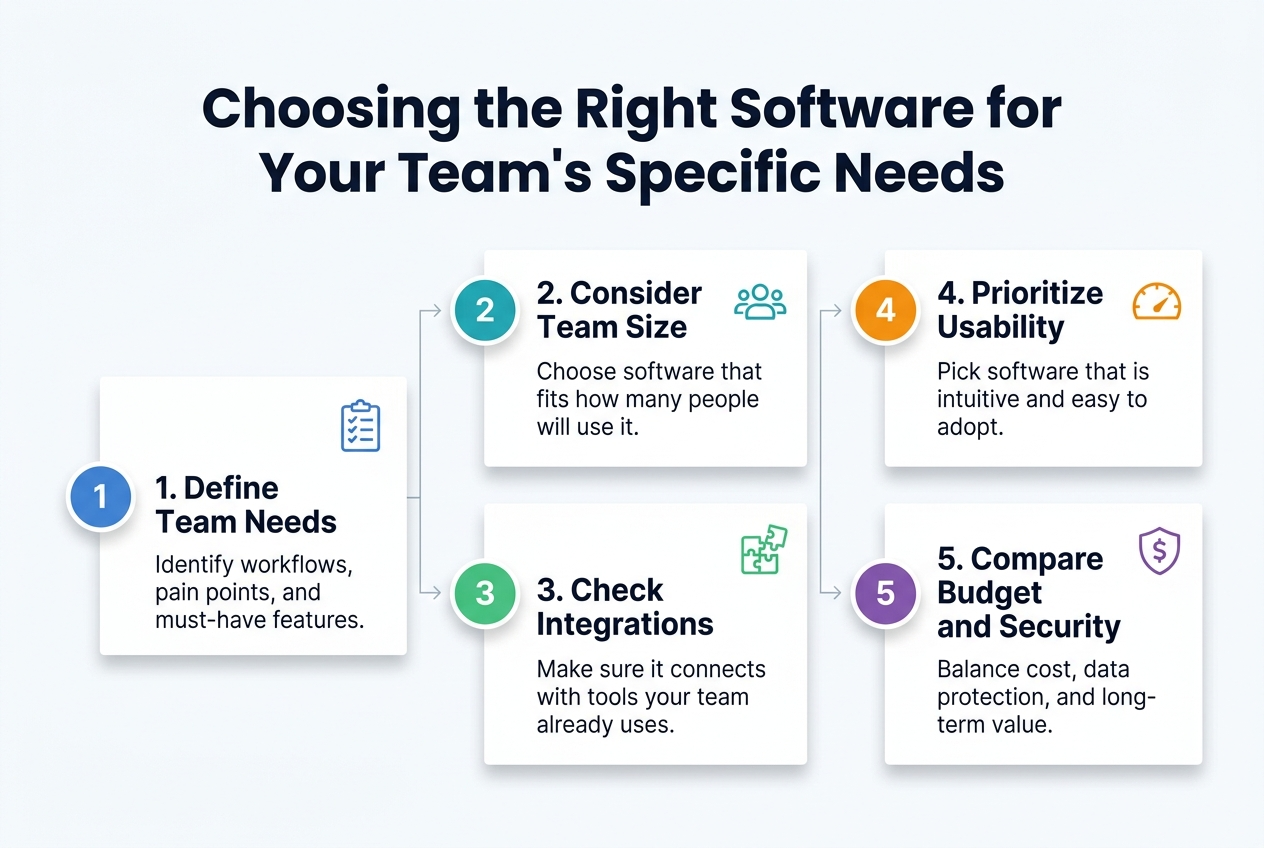
Municipality Requirements: Building Comprehensive Digital Twins
Municipal teams require 3D urban planning software that supports extensive, long-term city management initiatives. The foundation of effective municipal planning lies in developing comprehensive digital twin city planning systems that integrate multiple data layers seamlessly. These platforms must accommodate zoning regulations, infrastructure networks, environmental monitoring data, and demographic information within a unified framework.
Scalability becomes paramount when dealing with city-wide 3D city models. Municipal planners need urban planning technology 2026 solutions capable of handling vast geographic areas without compromising performance or data integrity. The software must support inter-departmental collaboration, enabling different municipal divisions to access, update, and share planning information efficiently.
Public engagement features are equally crucial, as modern municipal planning increasingly emphasizes citizen participation and transparency in the urban development process.
Real Estate Developer Focus: Financial Modeling and ROI Analysis
Real estate developers prioritize speed and financial precision in their 3D urban simulation workflows. The most valuable urban development software for this sector integrates sophisticated financial modeling capabilities, including comprehensive land development calculations and GREX analysis directly within the planning environment.
Rapid scenario generation stands as a critical requirement, enabling developers to compare multiple development variants within minutes rather than hours or days. This acceleration in decision-making processes directly impacts project viability assessments and investment timelines.
The software must produce detailed financial reports displaying costs, revenues, and ROI calculations in local currency formats. This data-driven approach to investment decisions requires digital urban modeling tools that seamlessly blend spatial planning with financial analysis, eliminating the need for separate systems and reducing potential errors in data transfer.
Architect and Designer Priorities: Creative Tools and Visualization
Architects and designers require 3D visualization urban planning software that enhances rather than restricts their creative workflow. Intuitive 3D design tools form the cornerstone of effective architectural planning software, enabling professionals to translate conceptual ideas into detailed spatial representations efficiently.
High-quality rendering capabilities are essential for creating compelling presentations that communicate design intent to clients, stakeholders, and regulatory bodies. The software must produce photorealistic visualizations that accurately represent proposed developments within their urban context.
Seamless compatibility with existing design ecosystems proves crucial for adoption success. Integration with industry-standard platforms including SketchUp, Revit, and BIM/IFC workflows ensures that smart city planning tools function as natural extensions of established creative processes rather than disruptive replacements.
Performance Considerations and Technical Expertise Requirements
Modern 3D urban planning software increasingly emphasizes user accessibility through intuitive interface design. This evolution allows planning professionals to achieve proficiency faster compared to traditional GIS or CAD systems, reducing training overhead and implementation timelines.
However, effective performance management requires strategic planning for large-scale model organization. Users must define appropriate geometry organization strategies for city-scale models, particularly when working with platforms like Revit, to prevent system slowdowns and maintain workflow efficiency.
Maintaining proper model hierarchy becomes essential when handling extensive corridor and surface modeling projects, such as those typically managed in Civil 3D environments. This organizational approach ensures that complex urban digital twins remain manageable and responsive throughout the planning process, supporting both detailed analysis and broad-scale visualization requirements.
Top Software Solutions Comparison for 2026 Planning Projects
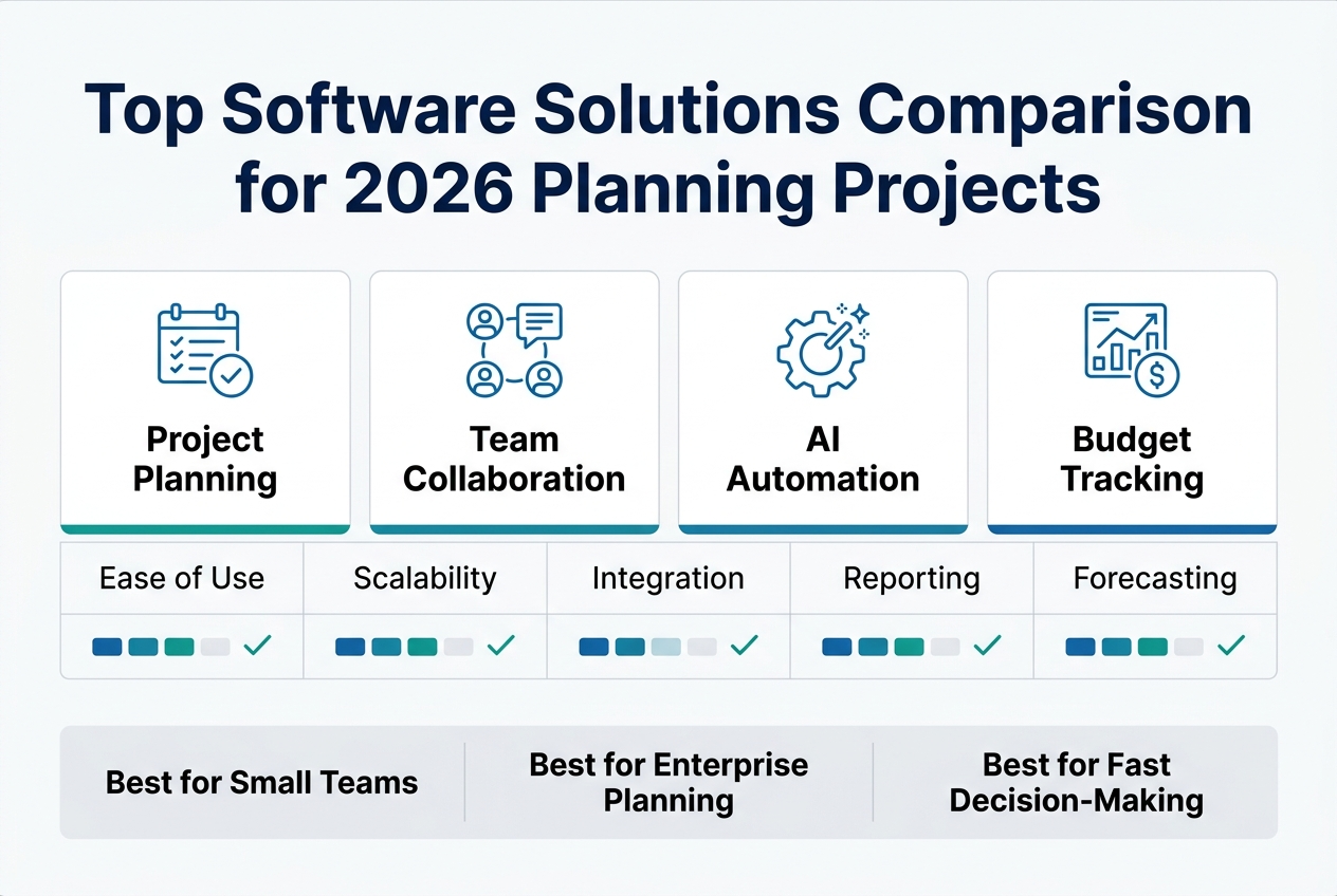
Infrastructure-Focused Solutions: Autodesk Civil 3D and Corridor Modeling
Autodesk Civil 3D stands out as the premier choice for 3D urban planning software when your primary focus centers on civil infrastructure development. The platform excels at creating and managing comprehensive civil infrastructure designs, making it indispensable for urban planning technology 2026 projects that prioritize transportation networks and site development.
The software’s standout feature lies in its corridor modeling capabilities, which enable assembly-based 3D geometry tied directly to surfaces and earthwork calculations. This functionality proves particularly valuable when developing road-and-grading-driven 3D city models that require precise volumetric analysis and cut-fill calculations. Urban planning teams working on infrastructure-heavy projects will find Civil 3D’s parametric corridor assemblies essential for maintaining design consistency across complex transportation networks.
Civil 3D’s strength becomes most apparent in projects where road networks, utilities, and grading operations form the backbone of urban development plans. The software seamlessly integrates surface modeling with corridor design, enabling planners to visualize how proposed infrastructure interacts with existing topography and environmental constraints.
BIM-Based Urban Design: Autodesk Revit for Parametric Planning
Autodesk Revit transforms digital urban modeling through its comprehensive BIM-based approach to urban design. The platform models buildings and infrastructure using parametric geometry, establishing rule-based relationships that automatically maintain design consistency throughout the planning process.
Revit’s defining strength lies in its Parameters and Families system, which drives parametric massing and generates consistent documentation outputs. This capability makes it the optimal choice for teams producing BIM-based urban precinct models where coordinated documentation remains critical. The parametric nature of Revit families ensures that design modifications cascade appropriately throughout the model, maintaining geometric relationships and performance criteria.
For smart city planning tools applications, Revit’s BIM methodology provides the structured data foundation necessary for advanced analysis and simulation workflows. The software’s ability to embed intelligent building data within 3D geometry creates rich information models that support both visual communication and quantitative analysis of urban development proposals.
Collaborative Platforms: Trimble Connect and BIMcollab Zoom
Modern digital twin city planning demands robust collaboration capabilities that extend beyond traditional file sharing. Trimble Connect addresses this need by managing project models, issues, and team collaboration through web-based 3D model markup and issue tracking anchored to specific model elements. This platform proves ideal for design teams collaborating on 3D urban proposals with model-based issue workflows, ensuring that feedback and revisions remain contextually linked to precise geometric locations.
BIMcollab Zoom complements collaborative workflows by focusing on review and measurement capabilities for BIM and 3D urban simulation datasets. Its zoom-based model navigation system enables measurement and annotation tied to exact model viewpoints, making it particularly effective for teams reviewing BIM-based urban proposals requiring geometry-specific markup and detailed issue documentation.
Both platforms provide essential web-based 3D model markup and issue tracking capabilities, enabling distributed teams to maintain design coordination throughout complex urban planning projects. The combination of cloud-based accessibility and model-specific annotation ensures that collaborative feedback remains actionable and precisely located within the 3D environment.
Interactive Visualization Engines: Unity and Unreal Engine
For 3D visualization urban planning that requires custom interactive capabilities, game engines provide unmatched flexibility and visual fidelity. Unity builds interactive 3D environments specifically designed for visualization and simulation applications, with editor extensibility achieved through C# scripts and custom inspector tooling as its standout feature. This makes Unity particularly suitable for teams creating interactive urban walkthroughs that require custom tooling and specialized user interfaces.
Unreal Engine focuses on rendering photorealistic 3D urban scenes and interactive simulations, leveraging Blueprint visual scripting and real-time physically based rendering to achieve cinematic quality visualization. The engine excels in projects requiring high visual fidelity and complex lighting scenarios, making it ideal for teams building interactive urban visualizations that demand photorealistic presentation quality.
Both engines enable interactive walkthrough visualization with extensible custom tooling, providing the foundation for immersive urban development software experiences. The choice between Unity and Unreal Engine typically depends on team programming expertise, visual quality requirements, and the specific interactive features needed for stakeholder engagement and public consultation processes.
Future Trends Shaping Urban Planning Technology
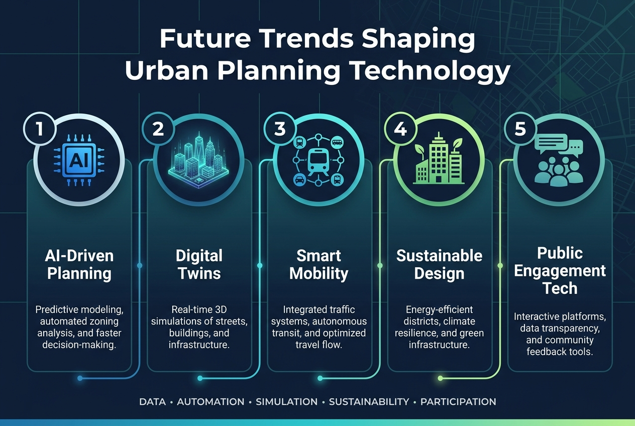
AI-Powered Generative Design and Automated Optimization
The landscape of urban planning technology 2026 is being revolutionized by artificial intelligence that extends far beyond simple automation. AI-powered generative design represents a paradigm shift where planners can define specific objectives such as maximizing sunlight exposure, optimizing housing yield, or minimizing construction costs. Rather than manually exploring limited design alternatives, AI systems can compute thousands of potential design solutions in a fraction of traditional timeframes.
This transformation dramatically reduces analysis time from weeks to hours, enabling urban planners to explore comprehensive design spaces previously impossible to investigate. The technology allows for strategic optimization where multiple objectives can be balanced simultaneously, creating more sustainable and economically viable urban development projects. The computational power behind generative design enables planners to test scenarios with unprecedented speed and accuracy.
True Digital Twins with Real-Time IoT Data Integration
Digital twin city planning is evolving beyond static 3D city models toward living, virtual replicas that maintain dynamic connections to real-world data streams. True digital twins integrate real-time information from IoT sensors, traffic flow monitors, and energy grid systems, creating operational tools that extend well beyond visualization.
These advanced systems serve as comprehensive city management platforms where policy impacts can be simulated with high accuracy. Urban planners can optimize traffic routes, manage emergency response scenarios, and test infrastructure changes before implementation. The continuous data streams require robust 3D urban planning software capable of processing and visualizing real-time information while maintaining system performance and reliability.
4D Planning: Adding Time Dimension for Project Phasing
The integration of temporal elements with spatial 3D urban simulation creates powerful 4D modeling capabilities that visualize entire project lifecycles dynamically. This advancement allows urban development teams to incorporate construction schedules and project phasing directly into their spatial models, creating comprehensive project visualization tools.
4D planning enables identification of logistical bottlenecks before they occur and provides clear communication mechanisms for complex timelines to stakeholders. Project teams can visualize how urban developments will evolve over time, ensuring proper coordination between different construction phases and infrastructure development stages.
Advanced Environmental and Financial Simulation Capabilities
The convergence of AI technology and true digital twins is driving unprecedented advancement in environmental and financial simulation capabilities within smart city planning tools. These systems now provide optimized sunlight exposure analysis through generative design algorithms, enabling more sustainable urban development decisions.
Financial optimization has become equally sophisticated, with systems capable of minimizing construction costs while simultaneously optimizing housing yield and development density. These advanced simulation capabilities provide urban planners with deeper insights necessary for creating both environmentally sustainable and economically viable urban projects, representing a significant evolution in digital urban modeling approaches.
Implementation Strategy and Common Pitfalls to Avoid
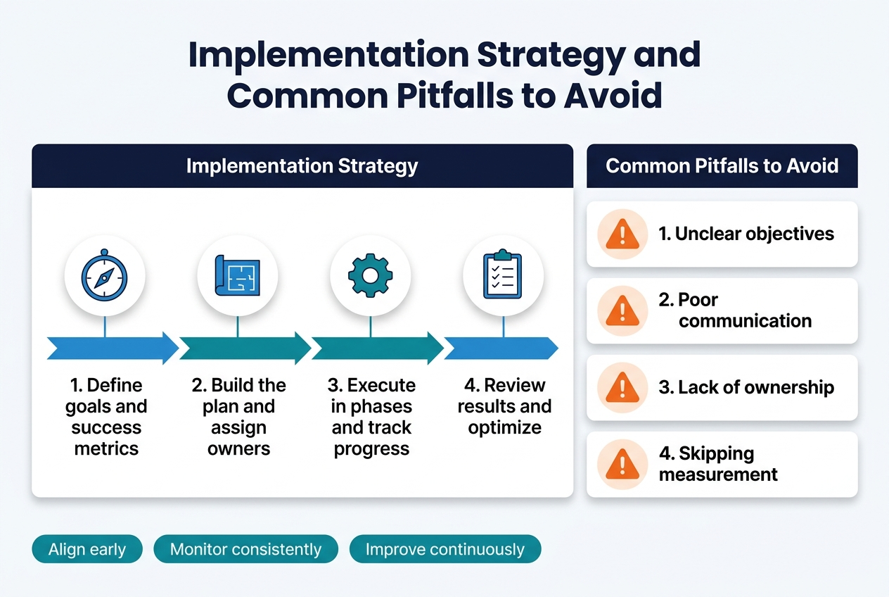
Matching Software Capabilities to Project Deliverables
The success of any 3D urban planning project hinges on aligning software selection with specific project deliverables. When your primary focus involves 3D streets, grading, and earthworks, Autodesk Civil 3D emerges as the optimal choice due to its specialized infrastructure capabilities. For projects requiring BIM-based precinct massing with coordinated documentation, Autodesk Revit provides the comprehensive building information modeling tools necessary for detailed architectural planning.
This strategic alignment ensures that your 3D urban planning software delivers maximum efficiency and accuracy for your specific deliverables. Rather than forcing a tool to perform outside its core competencies, selecting purpose-built solutions guarantees that your digital urban modeling efforts remain focused and productive.
Planning for Model Performance and Scalability
Performance planning represents a critical aspect of successful urban digital twins implementation. Large-scale models in robust platforms like Autodesk Civil 3D or Revit can significantly strain system performance without proper preparation. Early planning for workflow overhead becomes essential to maintain project momentum and team productivity.
Effective model and style management forms the foundation of scalable 3D city models. Defined geometry organization prevents performance bottlenecks that commonly plague complex urban planning projects. By establishing clear protocols for model structure and data management from project initiation, teams can avoid the costly delays and technical challenges that arise from poorly organized digital assets.
Setting Up Proper Collaboration Workflows
Effective collaboration in urban planning technology 2026 requires sophisticated tools that anchor markups and issues to specific model elements and viewpoints. Trimble Connect offers web-based centralized review capabilities that streamline team communication and project coordination across distributed teams.
For geometry-specific inspection requirements, BIMcollab Zoom provides specialized functionality for measurement and annotation during collaborative meetings. These tools ensure that smart city planning tools facilitate rather than hinder team collaboration, enabling precise communication about specific model elements and design decisions.
Avoiding Tool Mismatches and Workflow Inefficiencies
Common implementation failures often stem from using tools beyond their core strengths. Attempting infrastructure-grade earthworks with conceptual massing tools like Trimble SketchUp creates significant limitations, as these platforms lack the corridor modeling capabilities inherent in Civil 3D. This mismatch leads to workflow inefficiencies and compromised project outcomes.
Similarly, expecting native GIS and zoning analysis from 3D visualization urban planning engines like Unity and Unreal Engine without pairing them with dedicated GIS/planning analysis tools creates unrealistic expectations. These visualization engines excel at rendering and user experience but require integration with specialized analytical tools to provide comprehensive urban development software solutions. Understanding these limitations prevents costly tool mismatches and ensures optimal workflow efficiency.

The landscape of urban planning is experiencing a fundamental transformation as 3D modeling technology evolves from basic visualization tools into comprehensive digital twin platforms. The software solutions explored in this guide—from infrastructure-focused Civil 3D to interactive visualization engines like Unity and Unreal—demonstrate how modern planning workflows now integrate geospatial data, financial analysis, and stakeholder collaboration into unified environments. Success in 2026 planning projects will depend on selecting platforms that align with your specific objectives, whether that’s corridor modeling for infrastructure teams, BIM-based precinct development for architects, or AI-powered scenario generation for developers.
The future belongs to integrated, data-driven planning approaches where artificial intelligence optimizes design alternatives, digital twins enable real-time city management, and 4D modeling visualizes project timelines with unprecedented clarity. By understanding the essential features, avoiding common implementation pitfalls, and choosing software that matches your team’s workflow requirements, you’ll be positioned to deliver more efficient, financially viable, and sustainable urban development projects. The tools and strategies outlined in this guide provide the foundation for transforming complex planning challenges into clear, actionable insights that drive better cities forward.